Stops Along the Grade: Saluda
June 15th 2026
Saluda sits at the very top of the grade, more than 2,000 feet up, where the old Asheville-to-Spartanburg railroad finally crested the mountain. For its first several decades, the town ran on that railroad: trains labored up the climb, summer visitors rode in for the season, and the depot set the rhythm of each day.
The line is quiet now, but Saluda is not standing still. The town is already preparing for the Saluda Grade Trail, well before the first mile is built.
At a Glance
- State / County: North Carolina · Polk County
- On the corridor: At the top of the Saluda Grade · Planned route will run through downtown
- Chartered: 1881 · Population: ~743
- Claim to fame: The town at the summit of the Saluda Grade, long cited as the steepest standard-gauge mainline railroad grade in the United States.
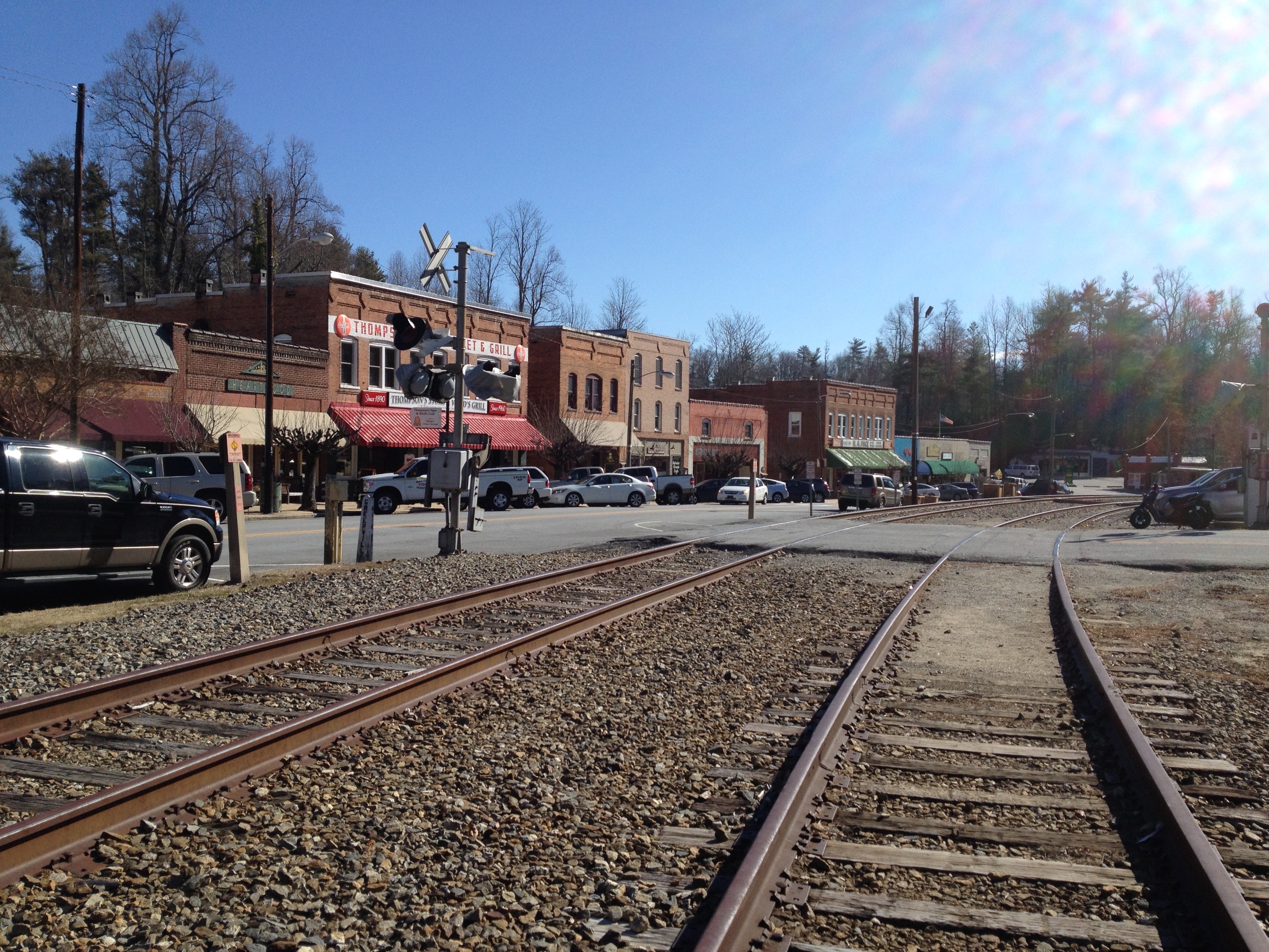
Where the rails ran
Before the trains, this was Pace's Gap, high ground owned mostly by two families, the Paces and the Thompsons, whose names fill nearly every Saluda Township deed from the 1870s and '80s. When the railroad reached the gap in 1878, it brought prosperity. A contractor named Andrew Tanner had the foresight to buy land near the right-of-way a year early, in 1877, and to build a commissary and the village's first hotel, the Mountain House. By February 1881, the legislature had chartered the town, with Tanner as its first mayor. Laid out "one mile square with the railroad exactly in the center," Saluda spread across seven hills (like Rome, the old accounts liked to say).
The name came down from the Saluda Mountains and the river below them; tradition holds it traces to a Cherokee word meaning Corn River. For roughly five decades, Saluda was an exclusive mountain resort, drawing wealthy Northerners and Lowcountry and Midlands families who summered in the big, airy Victorian houses on the hills. At train time, the depot came alive with hack drivers, surreys, and later touring cars jockeying for fares, and vendors carrying trays of fried chicken out to passengers still aboard. Many of those summer families' descendants still occupy the same houses today, at least part of the year.
What finally quieted the through-traffic wasn't decline but a road. When Interstate 26 was completed over Warrior Mountain in 1976, the big trucks moved to a distance. Saluda exhaled. The town became the unhurried, walkable, browse-and-shop place it still is.
Where the trail will run
From the summit, the old grade descends toward Tryon. It's the route the future trail will follow, the same descent laborers once knew when their tents and shanties lined the track from the bottom of the hill to the top.
It's fitting country for a trail because Saluda already lives outdoors. People fish the Green River for trout, bike the watershed's mountain roads, cool off in hidden swimming holes, and watch for birds at the Green River Preserve. A walking-and-biking corridor through the heart of town isn't a new idea here so much as a missing link.
Getting ready for the grade
This is where Saluda's story shifts from past to possibility. Corridor communities aren't waiting for the trail to be built before planning around it. At its February 2026 meeting, the county board of commissioners voiced support for Tryon and Saluda pursuing trail funding, and the county is already tracking trail-use data to prepare for what's coming.
The principle the whole project is built on is simple: the trail itself is regional, but trailside development is local, driven by each town in conversation with the region. The towns that engage early on parking, downtown connectivity, and business positioning shape the outcome rather than react to it.
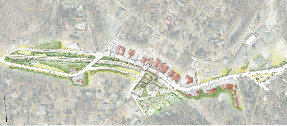
Saluda is doing exactly that. The town already has a downtown site concept that integrates the trail: trailside parking along Highway 176, a triangular parking area to the east, and McCreery Park as the central gathering point that ties it all together.
The old Norfolk Southern line still runs through Saluda, its tracks pointing toward the mountain grade that gave the trail its name. For now, you can park alongside them, right where the multi-use trail will be developed.
Steve Orr, Saluda's city manager, came to local government from real estate development, and he frames trail readiness the way an investor would. Long-term planning for the commercial district is already underway to spur investment in downtown and local businesses. The lesson Orr draws from other communities is plain: get positioned before the first rail is pulled, rather than scrambling once a trail is finished. The Saluda Grade Trail may still be five or ten years away, but for Orr that distance is the whole point, and as he sees it, the town has to "think five to ten years forward — or you're way behind. You might as well get out of the game."
The centerpiece of that planning is McCreery Park. Designed by Hunter Marks, it sits at the top of the grade, with future trail users able to arrive straight into the park on foot or by car. Accessibility runs through the redesign: the playground, trail access, and parking flow are all built to welcome people of all abilities, with a one-way access road threading the site. The trail segment here is planned to connect McCreery Park to Bell Park, knitting the route into Saluda's existing sidewalks and giving the town a more walkable, linked system.
Planners have looked to the Ecusta Trail, evolving nearby in the same region, for lessons on what works and what doesn't. The thinking on parking, trailheads, and traffic management is already underway, well ahead of the first wave of trail users.
That readiness extends to the streets themselves. Through an NCDOT Complete Streets planning study led by the Foothills Regional Commission's Rural Planning Organization and the City of Saluda, the town has been studying how to make West Main Street safer, more accessible, and better connected, with a streetscape that slows traffic, all while protecting Saluda's small-town character and historic downtown. In June 2026, the effort brought the community together for a multi-day design workshop at the Saluda Center, where drop-in sessions and public reveals invited residents, business and property owners, and elected officials to help imagine what downtown could become as the trail approaches. It's the same instinct at street level: shape the future on purpose, before the first trail user arrives.
.jpg)
For more on Saluda, visit our recent site walk recap: Walking the Grade: A Town, a Trail, and the Work of Becoming.
For more on the trail’s early planning efforts, dig into the Guiding Plans' one-page summaries: Community Engagement Plan · Economic Development Plan · Destination Marketing Plan.
Local voices
"The last thing you want with any of these projects is to be catching up. You want to be ahead of the game by at least two to five years, because investors and community members are going to start looking." Steve Orr, Saluda City Manager
"Economically, this will be a game changer for Saluda." Hunter Marks, Park Designer
Plan your visit
- Getting here: Take Interstate 26 to Exit 59 (Ozone Drive) and head toward downtown Saluda.
- Start at the Saluda Visitor Center: Pick up a walking-tour map and get your bearings before you explore downtown
- Good to know: Time your visit for a Friday between May and October and you'll catch the Saluda Tailgate Market, the weekly gathering where locals and visitors come for fresh produce, artisan crafts, and the kind of quirky finds you don't go looking for but leave with anyway. (And Thursday-Sunday, the Historic Depot Museum is worth a stop for how the railroad made this town.)
- Links: City of Saluda
- Been to Saluda? Tell us your favorite stop or tag us in your photos from town.
We'll see you down the grade!

Help Us Realize the Saluda Grade Trail
Across the United States, inactive rail lines have found new life as vibrant rail trails. Now, we have the opportunity to create a beautiful new trail along the historic Saluda Grade rail line!

A new rail trail that travels from the rolling countryside of Upstate South Carolina, through historic and vibrant small towns, and into the spectacular mountain scenery of Western North Carolina.
© 2026 Saluda Grade Trail Conservancy. All Rights Reserved | Privacy & Legal |
Site by: ALINE, A Marketing Company